Locations
New York Lakes & Regions
-
Western Adirondacks
Adirondack Park covers 6 million acres in northeast New York State. More than half of that – 3.4 million acres – is privately owned. The state owns the other 2.4 million acres.
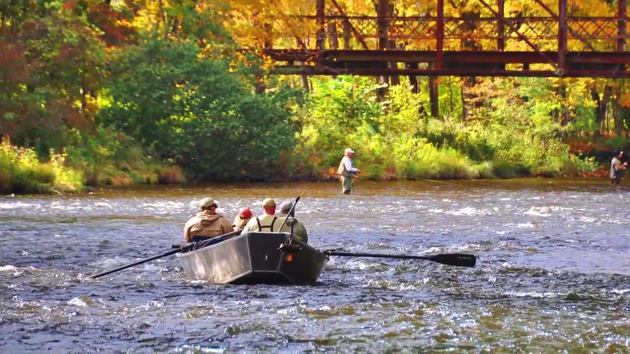
Among the park’s most remote assets is the Five Ponds Wilderness Area, 107,230 acres in the west-central region between Cranberry Lake and Stillwater Reservoir. Other than trails, mostly in the northern area, there are few signs of civilization. Primitive camp sites are available around the shores of Cranberry Lake in the northern part of the area, which are used mostly by paddlers on the canoe route. Cranberry Lake and Star Lake have boat launches, marinas and basic lodging services. But the overall feel is woods, water and wilderness.
The Oswegatchie River is both the inlet and outlet of Cranberry Lake. This river provides some of the Adirondacks’ finest canoe waters, including the Oswegatchie Flat Water Canoe Route. It runs from the inlet just south of Wanakena upriver into the High Falls and Five Ponds areas. The Oswegatchie route is regarded as one of the best deep woods wilderness canoe adventures anywhere. And it’s just one of the many canoe routes found throughout the western Adirondacks region.
The region also has excellent trout and smallmouth bass fishing. Whitetail deer and black bear are also abundant.
Most of the western Adirondacks region is dotted with state parks, designated wild forests, wildlife management use areas, wilderness areas, campgrounds and lakes with boat launches.
-
Lake Ontario Area
Upstate New York‘s northwestern border with Canada is Lake Ontario. This easternmost of the Great Lakes provides hundreds of miles of shoreline in upstate New York. It‘s the pre-eminent body of fresh water upstate. With more than a dozen state parks, beaches and wildlife areas spread out along the coastline, the area provides recreational and seasonal sports opportunities throughout the year.
The fishing in and around Lake Ontario is remarkable. Few areas in the Northeast offer the quality, quantity and diversity of fishing that anglers find in Oswego and Jefferson counties, ranging from trolling Lake Ontario to fly-fishing the area’s abundant streams and rivers for trophy trout, salmon and walleye. The area includes the Salmon River, whose headwaters flow from the Salmon River Reservoir on the Tug Hill Plateau. The Salmon empties into Lake Ontario at Port Ontario.
The natural white sand beaches in Oswego and Jefferson counties are some of the best on any body of freshwater. Sandy Island Beach State Park is in the center of a 17-mile belt of natural sand dunes stretching into both counties and is the only significant freshwater dune system in the Northeast. The area offers recreational opportunities for hikers, summer bird-watchers and nature-lovers, canoeists and kayakers.
Lake Ontario’s geography and environment offer photographers the opportunity to catch spectacular sunsets, which some travel magazines have ranked as among the best in the world.
Lake Ontario harbors with boat launches and marinas include Sacketts Harbor, Henderson Harbor, North Sandy Pond at Sandy Pond, Port Ontario, Mexico Bay at Mexico Point, and the Port of Oswego.
-
Salmon River
Salmon River Region in upstate New York begins in the east on the Tug Hill Plateau, and then flows west to Lake Ontario at Port Ontario, NY.
The beginning headwaters of the Salmon River start high upon the Tug Hill Plateau in areas that constantly receive over 300 inches of annual snow fall. This massive snowfall is the most any area receives in the United States west of the Rocky Mountains. In addition to the extreme snow fall the Salmon River is home to the Tug Hill aquifer. This gigantic submerged system of underground lakes and waterways support the very best salmon and steel-head trout fisheries found in all of Northeastern USA. Many U.S. and world record fish were caught from the Salmon River, or the where the Salmon River at Lake Ontario connect.
Starting in the Osceola (Lewis County) and Redfield (Oswego County), New York regions the Salmon River flows east first into the Salmon River Reservoir (Redfield, NY and Orwell, NY). The Salmon River Reservoir is an eight mile long wilderness lake formation with miles of protected shorelines buffered by State Forests. Numerous boat launch areas can be found on 3 of the 4 lake's shores. After the Salmon River Reservoir the river continues east though Orwell, NY through the Salmon River Gorge and over the Salmon River Falls. The Salmon River Falls is a 100 acres State Park Unique Area with hiking, picnic and viewing areas of the spectacular 110 foot dropping falls into a prehistoric deep gorge. The Salmon River Falls Park can be accessed from Falls Road in Orwell, New York.
After the dramatic water falls, the Salmon River flows into the Lower Salmon River Reservoir, roughly a 550 acre lake used for hydro power and recreation. Two public boat launches for non-motor boats exist along the lake's shores.
The Salmon River then flows east through the townships of Albion, NY and Richland, NY, running through the New York hamlets and Villages of Altmar, Pineville, Centerville, Pulaski and ending at Port Ontario's harbor. Various areas are open along the river for world class trophy fishing for King Salmon, Chinook Salmon, Brown Trout, Steel-head (Rainbow) Trout and Atlantic Salmon. The Salmon River New York State Fish Hatchery in Altmar, NY helps support millions of eggs and fingerings, assuring a healthy fish population becoming a stocking program that is second to none.
Drift boats fish for the prized sport fish year round. Fly-fishing only zones exist on the upper reaches of the Salmon River between Altmar, NY and the Lower Salmon Reservoir. Bald eagles and osprey fisher hawks are common aerial anglers adding to this pristine wilderness setting. Late summer and early fall Salmon will "stage" on Lake Ontario, gathering together in great numbers at Port Ontario where the river meets the lake, providing for some great salmon fishing by boat.
Besides great fishing the abundance of water supports excellent boating, kayaking and other water sports. Over 20,000 acres of state forest exist in the Salmon River area open for public hunting, hiking, exploring as well as fishing. Snowmobile trails and ATV trails run near the river and extend into the Tug Hill region and beyond. The area also has some of the most consistent snowmobile trails due to the hundreds of inches of lake effect snowfall the region receives. Wild game bird and white tail deer are plentiful too.
The Salmon River provides for a thriving tourism economy of local restaurants and lodging found in Pulaski, New York and the surrounding areas. Since 1998 Land First has delivered dozens of properties along the Salmon River and within the Salmon River region. Call us today for a tour of our current opportunities in this exciting recreational area, our office is only 10 minutes away this river.
-
Tug Hill Plateau
One of the unique geographic features of upstate New York is the Tug Hill Plateau. The 2,000-square-mile plateau stretches from near the eastern coastline of Lake Ontario to the western edge of Adirondack Park. Its northern boundary is near Watertown and extends to the Mohawk Valley on the south.
Tug Hill rises to an elevation of 2,000 feet and is one of the largest areas of unbroken hardwood forest in New York State. It’s also known for its pristine wetlands drained by coldwater streams that provide excellent trout fishing. The streams and melt water from Tug Hill’s famous 200 to 300 inches of annual snowfall constantly replenish aquifers under the hill’s surface. Many area residents drill their own water wells for private use.
Tug Hill, among the foothills of the Adirondack Mountains, experiences the highest average annual snowfall of any area in the United States east of the Rocky Mountains. The snow is considered a natural resource, supplying recreational opportunities throughout the season on miles and miles of snowmobile trails and cross-country ski trails, jeep trails, foot trails, abandoned highways and rural gravel roads. And many multi-use trails are enjoyed by snowshoe enthusiasts, cross-country skiers, snowmobilers and dog-sled mushers. Tug Hill also offers downhill skiing at Dry Hill and Snow Ridge ski areas. Once the snow melts, hikers and mountain-bikers take to the trails, along with bird-watchers. Recreation support facilities are located all around the plateau.
Some 17 state forests are designated on the Tug Hill Plateau, encompassing more than 70,000 acres of wooded recreational land for public use.
Tug Hill Plateau is drained by hundreds of brooks, dozens of streams and a few rivers. The major rivers and streams are the Mohawk River (Erie Canal), Salmon River, Mad River, Fish Creek and Sandy Creek and its branches.
Among the 4,000 miles of streams and rivers on Tug Hill, some flow through deep gorges that the locals call “gulfs.” These picturesque rock cliff canyons zigzag down from the plateau. Sandy Creek flows through Inman Gulf and Lorraine Gulf west toward Lake Ontario. Whetstone Gulf State Park is built in and around the Whetstone Gulf, a spectacular three-mile-long gorge cut by Whetstone Creek. The state park area between Tug Hill and the Black River offers what some observers consider the most scenic river canyon views east of the Rocky Mountains.
-
Thousand Islands
Thousand Islands are a famous tourist area and destination region located between Lake Ontario, Canada and northwestern New York State. The Saint Lawrence River flows though the Thousand Islands and is the outlet of the most eastern Great Lake - Lake Ontario. The Thousand Islands with the Saint Lawrence River is a navigable shipping seaway river, eventually emptying into the Atlantic Ocean. The Saint Lawrence River and the Thousand Islands are a natural boundary line between the countries of Canada and the United States.
The Thousand Islands (or 1000 Islands) are popular international vacation spot with waterfront island locations and waterfront areas along both the Canadian and New York shorelines. Excellent fishing, boating and summer lake recreation are available here. Gorgeous sunsets, bountiful wildlife, sparse populations, plentiful public parks and pleasant summer temperatures all make this an ideal scenic location for second homes, resort vacationers, camping, outdoor recreational activities and more.
Land First has inland lake properties and waterfront real estate near the Thousand Islands Region in New York State. Call for the most up to date information on our locations near this fantastic vacation location and must see recreational destination.
New York State & New York State Forests
-
Chateaugay State Forest
This 3,465-acre area in Northern Oswego County is on the edge of the Tug Hill Plateau, known for its seasonal recreational opportunities. In winter and summer the forest’s trails – ranging from 1 to 8 miles – are suitable for several activities. And the area’s two primary streams, the Orwell and Pekin brooks, provide excellent fishing opportunities.
Warm-season activities include hiking, mountain biking, horseback riding and rustic camping. In cool seasons when snow is abundant there are cross-country skiing and snowshoeing.
And of course, hunting and fishing are allowed in-season. Abundant populations of game throughout the forest include white-tailed deer, wild turkey and ruffed grouse. The forest’s streams offer steelhead and brown trout, as well as Chinook salmon.
The forest is also an excellent place for bird-watchers and photographers to view red-eyed vireo, wood thrush, eastern wood-pewee, blue jay, and other song birds. Red-tailed hawk also nest throughout the forest.
Among Chateaugay’s outstanding rustic natural landscapes are unique man-made features that date back to the mid-1800s. Early settlers who logged and farmed the area built many rock walls in the woods that can still be easily seen throughout the forest. It’s believed that the structures in Chateaugay are handiwork of Vic and George Waggoner of Orwell, whose stone work was well-regarded by residents of the surrounding area.
-
Greenwood Creek State Forest (St. Lawrence County)
The 1,009 acres of Greenwood Creek State Forest are in the town of Pitcairn. The land is primarily reforested land that had been cleared in the 1800s for farming and then abandoned during the Depression. This history is similar to many state forests in Upstate New York.
The forest is named for Greenwood Creek, which runs through the property and can be fished for trout.
The area is planted in hardwoods and evergreens such as white spruce, as well as red pine which is growing in the picnic area, a scenic spot equipped with fireplaces and other amenities built in the mid-1950s. Two camping sites are nearby.The forest includes a 1.8-mile nature loop that winds along Greenwood Creek, past a waterfall and through stands of hardwood and softwood trees. The trail descends to lower elevations of the forest then climbs back into the hardwoods and rock ridges. Another descent takes the trail into a spruce-fir wetland area along a small brook before completing the loop back at the picnic area.
A quarter-mile nature trail leads to an overlook above a wetland habitat through which Greenwood Creek flows.
-
Happy Valley Wildlife Management Area
These 8,895 acres in eastern Oswego County were cleared in the mid-1800s and farmed until the 1930s. When the Depression slowed farming in the area, the federal government acquired the land and began replanting the vacant farms with trees and developing the area to support upland game.
This involved adding man-made lakes, including the Mosher, Whitney and Long ponds. Seven waterfowl marshes were developed along with wetland habitat. The area features a public access waterway that includes St. Mary’s Pond and Lake Loraine for canoe, kayak and other non-motorized boat use.
The headwaters of Little Salmon River originate in the Happy Valley area. From there the Salmon flows toward Lake Ontario.
In addition to waterfowl habitat, the area includes forest with northern hardwoods such as sugar maple, beech, yellow birch and softwoods such as hemlock, white pine and spruce. The water features and woods attract wildlife including whitetail deer, hare, squirrel, beaver, muskrat, raccoon, mink, weasel, fisher and porcupine, as well as songbirds, waterfowl and game birds such as grouse, woodcock and wild turkey.
Happy Valley Wildlife Management Area connects with Stone Hill State Forest, adding 866 acres of public recreational woodland adjacent to the area.
-
Salmon River Falls Unique Area
A scenic 110-foot-high waterfall and picturesque 3,000-foot-long gorge are the outstanding natural attractions of the Salmon River Falls Unique Area in Northern Oswego County. The Salmon River Falls are 19 miles upstream from the mouth of the river where it enters Great Lake Ontario.
Until the 1860s, the falls were the upstream barrier to fish migration, offering tribes of the Iroquois Nation an abundant fishing ground for harvesting salmon. The salmon runs now end just south of the falls below the dam of the Salmon River Lower Reservoir.
The gorge includes sheer cliffs and steep slopes as high as 120 feet.
Amenities in the area include a parking lot and viewing sites overlooking the falls and gorge. During late winter and early spring spectacular amounts of water flowing over the falls provide amazing views and photography opportunities.
-
Sandy Creek State Forest
Sandy Creek State Forest sits on 538 acres of reforested land on the edge of the Tug Hill Plateau in Northern Oswego County. Its remote setting and lack of designated recreation trails offer habitat for a wide variety of wildlife for hunting and observing. Turkey, ruffed grouse and a wide variety of song birds and raptors are common, along with deer, weasel, fox, coyote, muskrat and squirrels.
Deer Creek is a pristine stream that flows for almost a mile through this state forest, providing seasonal trout and steelhead fishing as it makes its way to Lake Ontario.
-
Sandy Island Beach State Park
Sandy Island Beach State Park, in the Township of Sandy Creek, is on the shoreline that is part of the Eastern Lake Ontario Dune and Wetland System. The park offers parking, designated beach access, restrooms, picnic facilities, barbecue areas, as well as fishing and opportunities for hikers, bird-watchers, canoeists and kayakers.
Walk-overs and viewing platforms in the park protect the fragile coastal barrier environment, a 17-mile-long stretch of beaches, sand dunes, embayments and wetlands that extends north from western Oswego County to Jefferson County. The system includes the largest and most extensive freshwater sand dune formations in the Northeast.
During summer the beach is watched by lifeguards so families can have fun on the sandy beaches and in the waves of Lake Ontario.
-
Selkirk Shores State Park
With campsites overlooking a bluff on Lake Ontario in Pulaski, Selkirk Shores State Park offers spectacular sunsets as well as outstanding fishing, hiking and bird-watching. Selkirk Shores offers parking, barbecue areas and trails. Reservations can be made for campsites and the many picnic shelters under the towering pines on the shores of Lake Ontario. Anglers with boats can access the Salmon River and Lake Ontario at the Pine Grove site and boat launch. Larger boats can use the Mexico Point Boat Launch on the Little Salmon River at Lake Ontario south of Selkirk Shores. The park includes the Selkirk Shores Bird Conservation Area near Port Ontario where neo-tropical migratory songbirds concentrate along the lake during spring migration.
-
Southwick Beach State Park
Southwick Beach State Park near Woodville is the southernmost of the 30 state parks in the Thousand Islands Region of Upstate New York. The region stretches from the eastern tip of Lake Ontario north along the St. Lawrence River to Lake Champlain.
Spacious and popular Southwick Beach is also the northernmost state park of the Lake Ontario Dune and Wetland System, a 17-mile-long stretch of beaches, sand dunes, embayments and wetlands that extends from western Oswego County to Jefferson County. The system includes the largest and most extensive freshwater sand dune formations in the Northeast.
Southwick Beach is known for outstanding swimming and sunning on the long sandy lakeshore. Campers and day-users enjoy picnicking, hiking the trails and recreation on the sports fields. The park also offers 110 campsites. In winter, snowmobilers are permitted in the park and deer hunting is allowed south of the park entrance in season.
The park’s trails for hiking, cross-country skiing and snowshoeing are integrated with the trails in adjacent Lakeview Wildlife Management Area.
Lakeview also offers fishing, hunting, bird-watching, boating and fishing. Sandy and South Sandy creeks run through the area and are well known by fishermen for steelhead trout in the spring and Chinook salmon in the fall. Northern pike and yellow perch are often caught through the ice on several of the ponds, and anglers can also enjoy catching smallmouth and largemouth bass during the summer months.
Wildlife includes white-tailed deer, ruffed grouse, wild turkey, cottontail rabbit, red fox, beaver, mink, grey squirrel, eastern coyote and waterfowl.
Lakeview is a designated bird conservation area and is home to American bitterns, Caspian terns and northern harriers.
Three miles of foot trails and two viewing towers are in the area, as well as two dune walkover structures allowing visitors to catwalk over the fragile dunes and enjoy the Lake Ontario shoreline. An observation tower on Montario Point Road offers a bird's-eye view of the management area.
Other beautiful views can only be seen by boat. Three designated boat launch sites are available for canoes and kayaks or car top boats with a 10-horsepower limit.
-
Stone Hill State Forest
Reforested from farmland, the 866 acres of Stone Hill State Forest in eastern Oswego County offer a primitive setting for recreational activities such as hunting. The forest has few trails. An abandoned town road winds for almost a mile through the forest and is used by snowmobilers as part of the area's network of snowmobile trails. The only other path is a half-mile trail designated for ATV use for people with mobility impairments.
The forest includes hemlock swamps which provide wildlife habitat for hundreds of species of plants and animals. The abundance of resources provides opportunities for visitors to view wild turkeys, bald eagles, and grouse, as well as a wide variety of song birds and raptors. Stone Hill State Forest borders the Happy Valley Wildlife Management Area. Together the two public areas comprise 9,671 acres of state land for exploring.
-
Westcott Beach State Park
Westcott Beach State Park is in Adams on Lake Ontario’s Henderson Bay. The park is open for day use with activities such as seasonal swimming, a children's playground, picnic areas and hiking trails that do winter duty for cross-country skiing.
The park’s camp sites are on a bluff that offers scenic views. Away from the beach, the park is set on rolling, wooded hills with open, grassy meadows.
A small marina is adjacent to the long, sandy beach to accommodate boaters, as well as anglers out to catch a Lake Ontario black bass or other well-known Great Lakes fish such as steelhead.
-
Winona State Forest
This 9,233-acre state forest is on the boundary of New York’s southern Jefferson County and northern Oswego County. It’s on the western edge of the Tug Hill Plateau, known as one of the snowiest areas east of the Rocky Mountains, averaging 250 inches of snowfall a year.
The most outstanding and most-used feature of Winona is its system of more than two dozen trails. And with all the snow, wintertime is recreation time, offering snowmobiling, snowshoeing, cross-country skiing, dog-sledding and four-wheeling. In the warm months, the trails are open to hiking, mountain biking and horseback riding. For those who prefer recreation at a slower pace, Winona offers hunting, fishing, trapping and bird-watching.
Along with being one of New York State's top outdoor recreation areas, Winona State Forest is also a valuable timber resource.
See your next new property today, you deserve it!
Since 1998, we have helped hundreds of discerning folks, people like yourself, find dream property.
Call Toll-Free: 888-683-2626
Contact Us